Naturpark Beverin
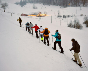
Winterwandern Tenna
Der Winterwander- und Schlittelweg führt mit einem leichten Gefälle zuerst durch offenes Gelände und dann durch den verschneiten Winterwald.
Winter hiking path
Time required: 1 hour 20 minutesLength: 4.40km
Der Winterwander- und Schlittelweg führt mit einem leichten Gefälle zuerst durch offenes Gelände und dann durch den verschneiten Winterwald.
Der Gantrisch ist ein Langlaufparadies schlechthin: Hier warten ein wunderbares Alpenpanorama mit Blick auf Eiger, Mönch und Jungfrau, der Blick auf den Thunersee, verschneite Wälder und 45km perfekt präparierte Loipen.
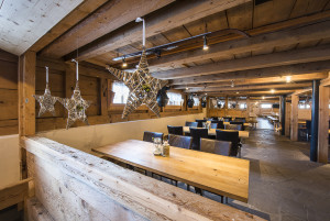
Die Maison Chasseral-Les Savagnières ist ein einladendes Haus in einer wunderschönen Umgebung unterhalb der Skipisten von Savagnières. Im Winter steht im ersten Stock ein geheizter Raum zum Picknicken zur Verfügung. Reservation für Schulen möglich.
Grillstelle mit Schutzhütte am Rossberg
In the winter season, the EGGUWEG can be made through the village from EGGU 7 to 16.
With 16 chairlifts and ski lifts and cable cars spread over 53 km of slopes, Sörenberg is the largest ski area in the canton of Lucerne.
The Rossweid in Sörenberg is the meeting place for families and nature lovers - in winter as well as in summer.
Auf das Brienzer Rothorn, den höchsten Punkt des Kantons Luzern, gelangen Sie bequem in weniger als 10 Minuten mit der Luftseilbahn.
Marbachegg at 1500 m - the sun terrace with the most beautiful panorama, where Emmental and Entlebuch meet.
Ski- und Schlittelvergnügen für gross und klein direkt vor der Haustür: Das bietet der Rotberg-Skilift zwischen Villigen und Mandach.
In winter, the LWS maintains an extensive network of cross-country ski trails on the Randen. The ideal cross-country skiing area offers a network of cross-country skiing trails including ski touring trails with a length of around 40 km.
The Reiat trail runs along the typical regional hilly landscape and the four districts of lower Reiat that are well worth seeing. Embark on a special expedition and walk through one of the most northerly regions of Switzerland.
For more than 20 years, hundreds to thousands of religious refugees arrived in Schaffhausen, where they were fed, treated and sent on with their travel money. On our search for traces in Schaffhausen, we follow their history.
Verschneite Landschaften, Stille und ein eindrückliches Naturerlebnis: Mit Schneeschuhen lassen sich die sanft geschwungenen Hügel zwischen Wasserfallen und dem Gebiet Passwang herrlich erkunden.
The sledge run begins at Gäschi. It is approx. 500m long and ends at Chummelti.
After a beautiful 2-hour ascent in the forest, the wonderful mountain panorama of Chäserstatt awaits you before you take the sledge back down to Mühlebach.
Der Winterwanderweg startet zwischen Mühlebach und Steinhaus. Der Weg führt die Forststrasse hoch nach Chäserstatt.
Der Winterwanderweg startet in Fäld. Von hier führt Sie ein gepflegter Winterwanderweg nach Brunnebiel.
Der Winterwanderweg startet in Ernen.
In summer you can go walking, rock-climbing or fishing on the Gemmi. In winter you can go tobogganing, walking or cross-country skiing... Enjoy the wonderful view from the Gemmi down into the valley!
Der Weg führt von Laupersdorf aus zuerst leicht bergauf und dann gemütlich am Hang entlang. Von hier aus hat man eine schöne Sicht auf das gesamte Dünnernthal. Die Bergwirtschaft Grossrieden bietet Erholung für müde Wanderer.
Cross through wooded pastures, then follow the trail up through the forest before arriving on the Pra-Cornet plateau and walking around it. Situated at 1670 meters, the plateau offers a stunning view of the surrounding summits.
The snow-shoe trail leads from Fäld through semi-open larch woods and over open meadows to the rear of Binntal and then up to Eggerboden and back to Fäld, one of the most beautiful hamlets in the Upper Valais.
Verzückende Ausblicke während der Schneeschuh-Tour auf der Sonnenterrasse Marbachegg sind hier garantiert.
Langlaufen mitten im Dorf!
The cross-country ski trails in the Diemtigtal, offering 22 kilometres of classic and skate-style skiing, will take you through forests and over snow-covered meadows.
Die Wanderung zur Skihütte & Alphotel Schwand ist für Jung und Alt.
Diese Loipe führt Sie vorbei am Hochmoor Mettilimoos und den imposanten Windrändern, während Sie leichtfüssig über die Langlaufspur huschen.
This snowshoe tour is pure nature: it leads through the Muscherntal valley past dense forests, over small bridges, thick logs and snow-covered stones. In view: the slopes of the Ättenberg and the summit of the Mära.
This somewhat more challenging tour leads through the stunning landscape beneath the Schrattenfluh and its striking karst formations. The hike ends at the Chlushütte (mountain hut), located at the foot of the Böli, where incredible panoramic views ac...
The chairlift takes you comfortably up the mountain, after which the varied, 5 km long toboggan run leads through the forest and across fields back down into the valley.
The cross-country ski trails in the Diemtigtal lead you through forests, along icy mountain streams and over snow-covered mats on 22 kilometres of classic and skating trails.
Marked, sunny snowshoe tour high up in the Diemtigtal. The circular hike takes you through snow-covered alpine areas and mountain forests and offers impressive views.
Snow crunching underfoot amidst a snowy winter landscape – the range of hills featuring the Napf on the right, a mountain backdrop with the Risetenstock, Schimbrig and Schafmatt on the left. And once you arrive at the First, a welcome Entlebuch-style...
Abwechslungsreicher Schlittelweg mit atemberaubender Aussicht.
Light-filled winter moments on the «Büchsewäg» on Grimmialp.
Gemütliche Rundloipe mit herrlicher Aussicht auf die Beichlen.
When it's grey below and the sun is shining from the blue sky onto the blanket of snow above, the Gantrisch Nature Park is just right. The trail leads along the cross-country ski trail from Schwarzenbühl to Otteleue. From there, the trail can be f...
Langlaufen in einer herrlichen Winterlandschaft entlang der Emme, umgeben von Hohgant, Schrattenfluh und Schibengütsch.
Cross-country skiers on the Salwidelifind panoramic trail find peace and solitude in the Entlebuch biosphere reserve. The trail passes through moorland terrain and offers delightful views of the surrounding mountains, including the Brienzer Rothorn, ...
The summer classic is also rewarding in winter as a mostly unmarked trail. From the watershed, follow the panoramic trail signposts. The view of the peaks of the Gantrisch range changes constantly, as does the view to the right over the Mittelland...
Auf dem Winterwander-Rundweg Rossweid-Schwarzenegg warten fünf inszenierte Fotoposten mit je einem spannenden Thema rund um die Fotografie auf Sie.
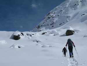
With a bit of luck, you will observe a colony of ibex through a telescope on this tour. There is reason to be happy: your ascent is rewarded with a great view of the Diemtigtal.
Schneeschuhtour auf Heiligkreuz mit grandiosen Aussichten.
Auf dieser Winterwanderung lernen Sie den Kraftort Heilikgreuz richtig kennen.
Die etwas andere Entdeckungsreisefür Kulinarikfans. Während dergemütlichen Winterwanderunglegen Sie mehrere Stopps ein umregionale Köstlichkeiten zu geniessen.
Enjoy a magnificent view of the hills and the Napf.
Auf den abwechslungsreichen Salwideli-Loipen mit wunderschönem Blick auf die umliegenden Berge wie Brienzer Rothorn, Schrattenfluh, Tannhorn und Hohgant fühlt man sich wie im hohen Norden.
Schneeschuhtour auf Heiligkreuz mit grandioser Aussicht.
Don’t fancy strenuous ascents? If so, this winter hiking trail is a real insider’s tip: with its sunny location, it’s ideal for all those who prefer a short tour that’s not too demanding. The vast majority of it is downhill and even takes you across ...