Naturpark Thal
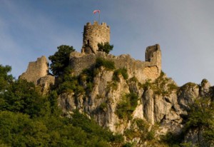
Ruins of Schloss Neu-Falkenstein
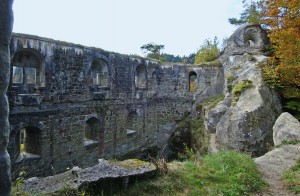
Neu-Falkenstein Castle was probably built in the early 12th century. During the 13th and 14th centuries it was the feudal seat of the counts of Falkenstein and Bechburg.
Castle
Neu-Falkenstein Castle was probably built in the early 12th century. During the 13th and 14th centuries it was the feudal seat of the counts of Falkenstein and Bechburg.
First class boats sailing for you on an enchanted river: The Doubs.
Cross the Doubs at Tariche with the famous flat-bottomed barque
Weitere Informationen: Centre de vacances in Tariche www.tariche.ch.
The Safien local history museum is more of a cottage than a house. It offers a good insight into the life and work of the ancestors.
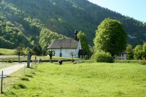
The "Church in Thall" was consecrated in 1441. Its compact from and granite roof make it seem as if had grown out of the ground on this spot.
The Church of St. Pankratius lies on a delightful hill between Aedermannsdorf and Matzendorf. It was built in 1520 in the late Gothic style and was extended in 1781. Today it is a popular wedding church.
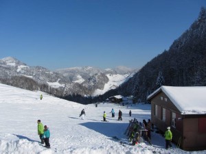
Skilift Hohe Winde, Bügellift für die Grossen, Pinocchio-Lift für die Kleinen, Winterwanderwege und warme Gaststuben für alle.
Wir organisieren Ausflüge in die stille Natur des lebendigen Thals
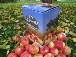
Ein Produkt mit dem Label « Schweizer Pärke »: Apfelsaft.
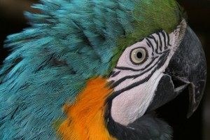
The Ambigua Bird Park is especially committed to parrots, parakeets and other exotic birds.
"s isch äben e Mönsch uf Ärde - Simelibärg!" - This is how the oldest and most famous folk song in Switzerland begins. Alive to this day. You can learn more about this and about the short skirts of the Guggisberg traditional costume in the museum
Die Ruine Grasburg steht auf einem Felssporn an der Sense. Im 16. Jahrhundert wurde das herrschaftliche Schloss Schwarzenburg mit Material aus der Grasburg erbaut.
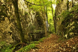
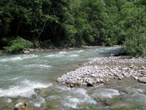
Wolfsschlucht (gorge of the wolf) is a cantonal nature reserve and demonstrates here the enormous power of nature. A trial runs between the steep and overhanging cliffs through the narrow and wild romantic gorge with caves and erosions.
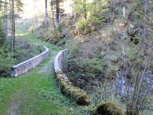
Über mehrere Kilometer erstreckt sich die über 1000-jährige Trockenmauer auf der zweiten Jurakette. Seit je her bildet sie eine geografische und kulturelle Grenze. Sie ist auch wertvoller Lebensraum für seltene Tiere und Pflanzen.
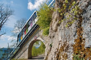
From Mont-Soleil, a fast and pleasant trip by funicular railway down to the bustling little town of Saint-Imier (population 5,000).
Located in the canton of Vaud, but close to Geneva and France, L'Auberge de la Rippe combines the charm of an elegant 1876 building and a calm setting.
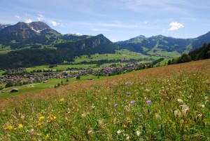
The trail connects the two villages Charmey and Crésuz. It gives the walker a wonderful panorama view of the Jaunbach valley and the valley of Javroz.
The Etang des Royes is the baby brother of the Etang de la Gruère and is visited less often. It is embedded in green and more remote, but has a great deal of charm and offers unique tranquillity.
The trials leads to Châtel-sur-Montsalvens in a superb course that is listed in the inventory of historical traffic routes in Switzerland. Afterwards the trail descends to the Broc chocolate factory and to Gruyère.
From the middle of the village the trail descends to the Lac de Montsalvens, then along the lake to the dam of Châtel-sur-Montsalvens - the first arch dam in Europe. The trail then leads to the little town of Gruyère.
The trail leads from the little town of Gruyère past the Maison du Gruyère and then further in the direction of the Saane valley. Then it ascends again between forest and meadows to the village of Estavannens.
Geschäftsstelle Parc du Doubs
Region Solothurn Tourismus
Whether alone, as a couple or as a family: everyone is welcome and will find relaxation, time for reflection or for conversation.
The trail connects the two villages Estavannens and Grandvillard. In the latter the house of Banneret is located, which was built in 1666.
The trail leads out of Grandvillard , then over the stream of Les Marais to below the waterfall and to the grotto, which is a place of Gruyère pilgrimage . In the village centre there is a well with its imposing cupola.
Starting at the Lessoc well (1796), whose cupola was a gift of a cheese merchant from Lyon, the trail leads to Montbovon.
The trail leads from the village of Neirivue through fields and woods to the hamlet of Sciernes d'Albeuve and then descends again to Montbovon.
From Montbovon the trail ascends on the left side of the valley into a pretty little valley. This historical trail leads as far as the Pont du Pontet, one of the oldest bridges in the Canton of Freiburg (17th century).
öffentliches WC Mathon
We invite you to enjoy above all homemade and regional products in a quiet and cosy atmosphere.
Tourist office - Saignelégier
The trail starts with the ascent to the Col de Jaman. It leads up over alpine meadows. The alpine huts have traditional shingle roofs. The trail then descends again to the village of Les Avants.
The stunning Bergwirtschaft Hinter Brandberg, high up the mountain, offers panoramic views stretching as far as the Alps.
The walk begins at the storage cellars of L’Etivaz, where all the Etivaz AOP cheeses mature. Les Moulins is reached over diverse cow meadows belonging to the alpine farms, of which some produce Etivaz AOP.
In Rougemont, formerly a Cluniac location, a church built at the end of the 11th century can be admired with its wooden façade and magnificent paintings. The trail leads along the banks of the River Saane to the hamlet of Les Combes.
Viel zu erzählen hat der charmante alte Kasten Stelvio. Auf das um 1600 erbaute, direkt an der Kirche stehende Bauernhaus in Sta. Maria wurde um 1912-1914 das Hotel Stelvio aufgebaut.
Tourist office
Tourist office
The walk round the Etang de la Gruère is easily accessible for young and old. A beautifully laid-out trail (wood shavings and board walks) reveals new and wonderful views at every step around this fantastic moorland lake.
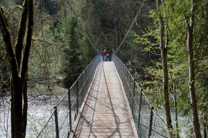
Starting in Les Combes, the trail leads over meadows and pastures down to the Saane river and crosses it. The trial then goes over an old suspension bridge before one arrives in the village centre of Château-d'Oex.
From the village of Rougemont the trail ascend to the hamlet of Ciernes Picat. The walk leads past several alpine farms that produce Etivaz AOP up to the saddle, and then it descends again to Château-d'Oex.
From Château-d'Oex, one proceeds along the railway track and the stream, over meadows and pastures, until the village of Les Moulins is reached, where BIO Gruyère cheese is produced.
Venison and wild boar meat products from the Reiat and Klettgau
The cheese shop with regional products
The little shop in the middle of the village
- Clothing and accessories
- Bike rentals
- Repair and troubleshooting
- Maintenance of your all-brand bike
The walk goes over pastures on the floor of Les Moulins valley to the bank of the River Saane. It continues to the old transit road, that in former day connected the Riviera or the Gruyère country with the Pays-d’Enhaut and Saanenland.
From Rossinière the trail follows the old historical road on the left bank of the River Saane; it is shady and wooded. From 1840, stagecoaches travelled along the route to La Tine.
The route ascends an alpine road up to the mountain ridge underneath La Petite Chia Alp. From there the trail descends to Montbovon and the the Hongrin valley, an essential passageway for the Gruyère and Pays-d’Enhaut alpine farmers.