Schweizerischer Nationalpark
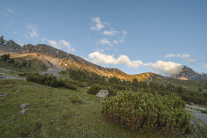
01 Alp Trupchun
Open
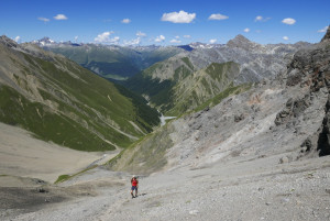
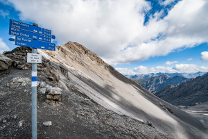
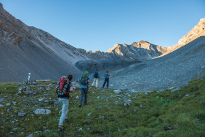
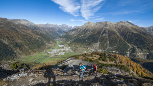
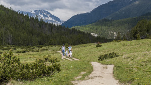
One of the most frequented walks in the Park, in particular during the rutting season at the end of September.
Hiking trail
Time required: 3 hoursLength: 9.50km
One of the most frequented walks in the Park, in particular during the rutting season at the end of September.
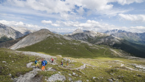
Quite steep in the upper region, this is a route for those who are sure-footed on slippery scree.
This challenging 8-hour alpine excursion is only recommended for sure-footed walkers with a head for heights.
A challenging ascent of the highest peak that lies entirely within the National Park.
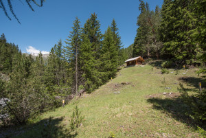
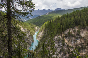
This short hike leads through a sparse spruce-larch-pine forest with some impressive giant trees.
This varied walk requires a certain amount of effort and is not often undertaken. It offers wonderful views into the Cluozza valley, towards the Engadine and the dominating peak of Piz Linard.
Comparable to a Swiss Alpine Club mountain hut, Chamanna Cluozza is the only hut within the Park that offers overnight accommodation; with 61 sleeps.
One of the Park’s classics: this is a walk that gives plenty of opportunity to observe animals, many species of flora, and fascinating geological features such as dinosaur tracks or fossilised corals.
This easy walk takes us from the Pass dal Fuorn road down to the Ova Spin compensation reservoir.
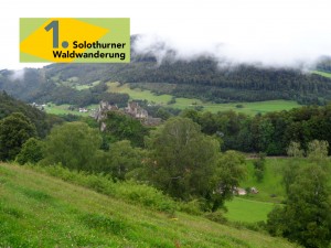
Durch Bärlauch und Märchenwald - diese Wanderung bietet die ganze Faszination der Jurawälder in einer Etappe
Our wilderness walk!
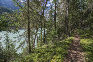
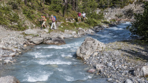
Less frequented than other routes, this relatively flat walk will suit those who are looking for a bit of peace and quiet. Woodland and waterside landscapes accompany us along its length.
On this walk we go along a stretch of the historical former route to Livigno, where horse-driven carts still travelled in the early days of the Park.
Provided the snow has already melted, it is possible to do this easy circular walk around the hillside of Las Crastatschas as early as mid-May. The first timid signs of spring can be seen then, and ungulates have not yet moved to the higher regions.
This 2-hour walk follows the former Pass dal Fuorn road, offering pleasant views of the Pass dal Fuorn landscape with its typical stretches of mountain pine forest.
This trail leads from the customs house at Punt la Drossa/P4 to Il Fuorn/P6; we walk alongside the delightful Fuorn stream that manages most of the time to drown the sound of traffic on the Pass dal Fuorn road.
Many people consider this to be the most enjoyable walk in the National Park.
In the first section, from Il Fuorn to former P7, we see the impressive contrast between a humid alpine mixed forest and a dry mountain pine forest.
This well-frequented route has become increasingly popular since bearded vultures were released here between 1991 and 2007.
The walk over Fuorcla Val dal Botsch leads from the Pass dal Fuorn region to Val Mingèr, via a 2676 m high pass. It is normally passable from end of June to end of September.
The last bear in Switzerland was shot in Val Mingèr in 1904. Unfortunately the Swiss National Park was only founded 10 years later and could not, therefore, offer any refuge for this creature.
Kreten, Schluchten, Wald - ein echtes Highlight im Naturpark Thal.
Val Tavrü is of historic importance to the National Park. From 1911 to 1936, when the whole valley was part of the Park, it formed the boundary to our vast nature reserve.
23 lakes, crystalline bedrock, rare plant species and a fantasy world of dragons and dwarfs all contribute to Macun’s renown as one of the pearls of the National Park.
This route leads from Schaffhausen up to the Jura heights. From there you follow a circular path into the Eschheimtal valley. The path is, sometimes wooded, sometimes lined by meadows and fields.
Diese Gratwanderung führt auf dem Albisgrat mit Blick über den gesamten Naturerlebnispark Sihlwald auf der einen Seite und toller Fernsicht ins Knonaueramt auf der anderen Seite vom Albispass bis nach Sihlbrugg.
A scenic hike with distant views. In addition there are great views of the Sihlwald wilderness, the first nature discovery park of Switzerland.
Der erste Teil dieser Wanderung bietet viel Weitsicht und tolle Ausblicke über den Sihlwald. Im zweiten Teil tauchen Sie dann direkt ein in die Wildnis des ersten Naturerlebnisparks der Schweiz.
Kurzer Spaziergang zum Aussichtsturm Hochwacht mit unvergleichbarem Ausblick über den gesamten Wildnispark Zürich.
Welch ein Kontrast! Kaum zehn Kilometer von Zürichs Zentrum, von Shoppingzentren und Banken, liegt einer der ursprünglichsten Wälder und der erste Naturerlebnispark der Schweiz.
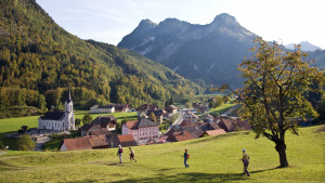
The trail starts with the ascent to the Col de Jaman. It leads up over alpine meadows. The alpine huts have traditional shingle roofs. The trail then descends again to the village of Les Avants.
The walks starts with an ascent to the Col de Jaman. The trail leads over meadows with cairns and past alpine huts with shingle roofs. The trail then descends to the village of Les Avants.
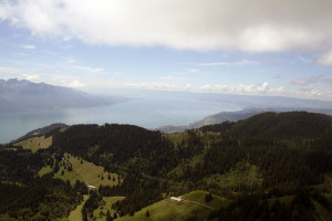
This stage is the only one on the Grand Tour des Vanils to offer a magnificent glimpse of Lake Geneva (from the Col de Jaman) and along the slopes of the Cape au Moine.
Two passes, two worlds
From the Allières relay station to the Montbovon crossroads
The mountain trail from Ausserferrera to Sufers leads across the Nursera and Schwarzwald Alps with magnificent views of the Hinterrhein valleys of Val Ferrera and Rheinwald, which are characterised by alpine farming and the former mining industry.
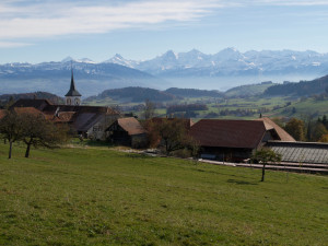
Vom Aaretal über den Belpberg, hinab ins Gürbetal und wieder hinauf auf den Längenberg. Bei dieser Route zeigen sich immer wieder grossartige Aussichten, wie aber auch kleine Ortschaften im Berner Gürbetal.
Noch ein letzter Blick der Berner Alpen geniessen, bevor der Abstieg in den Schwarzwassergraben folgt. Nach der Überquerung der ältesten Betonbogenbrücke der Welt, wird Schwarzenburg erreicht. Über dessen Plateau, Wälder und Wiesen führt der Weg a...
Hügellandschaft, Sensegraben, eine Kantonsgrenze und die verdiente Erfrischung im Bergsee - all dies bietet die 19. Etappe des Alpenpanoramawegs.
Vom lieblichen Schwarzsee zum Breccaschlund und in die spitze Kalklandschaft der Greyerzer Alpen, über den flachen, von Gletschern ausgehobelten Euschelspass nach Jaun ins einzige deutschsprachige Dorf des Bezirks Gruyères.
Die alte Averserstrasse von Juf zur Rofflaschlucht steht als historischer Verkehrsweg unter dem Schutz der Eidgenossenschaft und des Kantons Graubünden.
Die alte Jakobswegroute ist ein Wander- und Pilger-Klassiker im Naturpark Gantrisch, obwohl sie nicht mehr zur aktuellen Jakobsweg-Route gehört.
Discover the historical trails over the Randen, leading you through pleasant forest valleys up to the heights of the Randen with the vast stretch of the Zelgli meadow.
A huge palette of natural diversity awaits you. Our tip: Leave room for your own impressions and discoveries and sharpen your eye for the inconspicuous.
Even without much hiking experience this hike can be done easily. Although this is one of the easier hikes, the view is priceless.
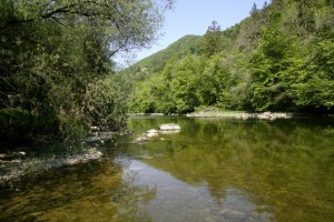
This hike does full justice to its name. The trail leads from Les Brenets near La Chaux-de-Fonds to St. Ursanne, almost always alongside the River Doubs and crossing the Doubs Regional National Park from west to east.
From Les Brenets, follow the Doubs to the impressive Saut du Doubs, a 27m high waterfall. The river widens into a mineral world to the Châtelot dam before sinking into deep gorges.
This stage goes through a thick and wild forest, house of many plant and animal species . It is hard to imagine just how much industry there was here 200 years ago. Today, only a few signs of this intense industrial activity remain.
Enjoy the water along the quiet broad pathways, an ideal spot to observe the river's activity. Amid the silent fishermen, you can admire the trouts, pikes and aprons, also known as Roi du Doubs.
Leave the wild nature behind you and slowly come back to the real world before reaching the medieval town of St-Ursanne. There, the Doubs makes a sharp turn; perhaps this is where it gets ist name from - dubitus meaning the hesitant in Latin.
The trail starting from the Joux valley at the foot of the Jura, leads through the regional Jura Vaudois Nature Park to the highest summit of the Swiss Jura, Mont Tendre (1,679m), with a magnificent view of the Alps and the Lake of Geneva.