Navigating the Swiss Parks Website

Hikes

In the Swiss parks
Show filter

All Parks

All offers

The offer is suitable for

Accessibility

Routes: Time required

Routes: requirements

477 offers
Landschaftspark Binntal

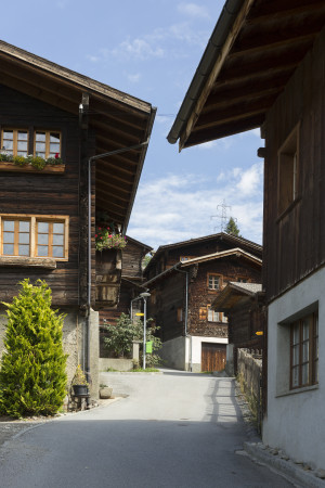
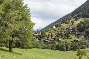
Cultural trail in and around Grengiols (circular route)

Currently partly closed

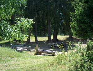
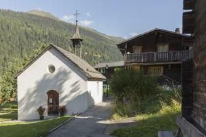
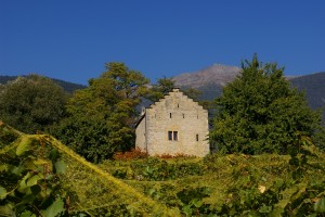
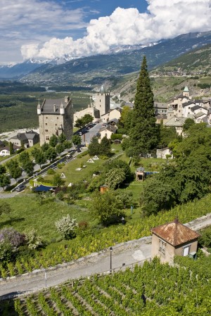
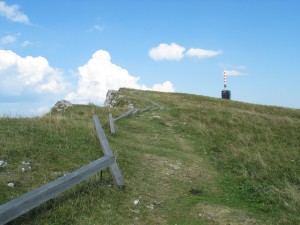
Circular trail starting in beautiful Grengiols in the direction of Tulpenhügel. After a short hike, you reach Bächernhäusern and then return to the village.
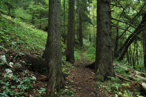
Hiking trail
Time required: 45 minutesLength: 2.20km
Landschaftspark Binntal

Grengiols – Bister cultural trail (circular route)

Open

Short hike starting in the picturesque village of Grengiols to the small, beautiful village of Bister and back again.

Hiking trail
Time required: 2 hoursLength: 6.20km
Landschaftspark Binntal

Wasen – Hockmatta – Blatt – Schärtbrigga – Steinmatten

Currently partly closed

Short hike from Wasen down to the beautiful Hockmatta and on to the picturesque Steinmatten.

Hiking trail
Time required: 1 hour 45 minutesLength: 4.60km
Landschaftspark Binntal

Cultural trail Lax - Deisch - Grengiols railway station

Open

Beautiful hike starting in Lax via Deisch to Grengiols

Hiking trail
Time required: 1 hour 30 minutesLength: 4.30km
Landschaftspark Binntal

Mühlebach cultural trail

Open

Short circular hike through the idyllic village of Mühlebach

Hiking trail
Time required: 40 minutesLength: 1.50km
Landschaftspark Binntal

Hydropower cultural trail

Open

Beautiful hike around the theme of water, starting in Mühlebach and ending at Wasen

Hiking trail
Time required: 2 hoursLength: 5.00km
Landschaftspark Binntal

Steinhaus cultural trail

Open

Take the postbus to Mühlebach or Steinhaus or park in Steinhaus. The starting point is at the street gallery before Steinhaus. From there, the cultural trail leads back to the village of Steinhaus and on to the former hamlet of Richulschmatt.

Hiking trail
Time required: 50 minutesLength: 2.00km
Parc naturel régional Gruyère Pays-d'Enhaut

Mittelberg – Gastlosen Express

Du versant bernois au versant fribourgeois des Gastlosen

Hiking trail
Time required: 2 hours 45 minutesLength: 7.60km
Naturpark Pfyn-Finges

Via Cook: Sierre - Leuk

The artists' village of Veyras, where Rainer Maria Rilke lived, the Raspille Gorge, the Valais Wine Museum in the Zumofenhaus in Salgesch and the village of Varen are all well worth seeing. Another possibility goes through the forest of Pfyn/Finges.

Hiking trail
Time required: 4 - 6hLength: 14.00km
Naturpark Pfyn-Finges

Via Cook: Leuk - Leukerbad

You reach Leukerbad on historical mule tracks and an old railway route past the St. Barbara wayside chapel and over a 16th century bridge. At your destination, a visit to one of the thermal baths is highly relaxing.

Hiking trail
Time required: 4 - 6hLength: 10.40km
Naturpark Pfyn-Finges

Leukerbad - Gemmi Pass

The mule track was constructed by the Tyroleans in 1739/41 and leads through the Daubenwand, which even today seems insurmountable, and up to the Gemmi Pass. With a bit of luck you might see bearded vultures.

Hiking trail
Time required: 2 - 4hLength: 4.70km
Naturpark Pfyn-Finges

Via Cook: Gemmi - Kandersteg

Visitors rave about the splendid views of the Monte-Rosa massif, the Weisshorn,Matterhorn and Dent Blanche.The mule track still leads past the Dauben Lake to Schwarenbach mountain hotel, which is steeped in history, and then further on to Kandersteg.

Hiking trail
Time required: 4 - 6hLength: 15.50km
Parc Ela

Parc Ela Trek

The trek runs at an alpine level without descending into the valley. 5 new accommodations have been created for this trek. Peace, spectacular mountain scenery, alpine life and tasty food are guaranteed.

Hiking trail
Time required: 87 hours 35 minutesLength: 226.70km
Jurapark Aargau

Rebweg Auenstein

Wer seine Wanderung durch malerische Rebberge nutzen möchte, um sich weiterzubilden, ist auf dem Rebweg Auenstein genau richtig: Er führt durch die Wälder, Felder und Rebberge oberhalb von Auenstein.


Theme trailHiking trail
Time required: 55 minutesLength: 3.46km
Parc du Doubs

Au fil du Doubs - Stage 1

From Les Brenets, follow the Doubs to the impressive Saut du Doubs, a 27m high waterfall. The river widens into a mineral world to the Châtelot dam before sinking into deep gorges.

Hiking trail
Time required: 4 - 6hLength: 18.30km
Naturpark Pfyn-Finges

Tour around the ponds

Open pine forests, picturesque pools and rare flowers
Distance 1.5 km
Time required 0 h 30
Height difference: ascent 50 m
Height difference descent 50 m

Hiking trail
Time required: 1 hour 30 minutesLength: 1.50km
Naturpark Beverin

viaCapricorn - 1st stage

The viaCapricorn leads in 3 stages across the area of the Safien-Rheinwald ibex colony. On the 1st day you walk through beautiful alpine meadows, past Piz Beverin and the turquoise Schottensee. If you are lucky you will see the ibexes!

Hiking trail
Time required: 7 hoursLength: 21.00km
Naturpark Beverin

viaCapricorn - 2nd stage

The viaCapricorn leads across the area of the Safien-Rheinwald ibex colony. On the 2nd you walk through Safiental, which is characterised by the Walser culture. You will find barns burned brown by the sun, solitary located hamlets and tranquility.

Hiking trail
Time required: 5 hours 30 minutesLength: 17.00km
Naturpark Beverin

viaCapricorn - 3rd stage

The viaCapricorn leads in 3 stages across the area of the Safien-Rheinwald ibex colony. On the 3rd day you climb steeply up to Alperschälli. In the region of the ibexes you will find crystal-clear mountain lakes and enjoy the view down to Schams.

Hiking trail
Time required: 6 hours 30 minutesLength: 19.00km
Parc naturel régional Jura vaudois

La Grande Traversée - Stage 1

From St-Cergue, the trail leads through typical Jura wooden pastures before reaching the Marchairuz pass. You might even run into some wood ants, Jura Vaudois Park's symbol.

Hiking trail
Time required: 4 - 6hLength: 17.00km
Parc naturel régional Jura vaudois

La Grande Traversée - Stage 2

From the Marchairuz pass, the trail follows the Jura crest to its highest point, the Mont Tendre (1679m) which offers an outstanding view. You then go back down to Montricher.

Hiking trail
Time required: 4 - 6hLength: 14.00km
Parc naturel régional Jura vaudois

La Grande Traversée - Stage 3

From Montricher, the trail continues along the foot of the Jura and its authentic villages offering beautiful views on the Alps. La Grande Traversée ends at Romainmôtier, a medieval town famous for its abbey.

Hiking trail
Time required: 2 - 4hLength: 16.00km
Naturpark Beverin

Tenner Chrüz - circular hike

The hike from Tenner Chrüz is a leisurely walk, but it still rewards one with an imposing view of the deep Ruinaulta gorge over to Flims and to the Ringelspitz (3247 m).

Hiking trail
Time required: 3 hoursLength: 6.00km
Naturpark Beverin

Heinzenberg Ridge Hike

Obertschappina - Glaspass - Glasergrat - Lüsch - Bischolpass - Tguma - Präzer Höhi - Präzer Alp - Prau da l'Alp - Saloms - Pranzolas - Prau Sdunon - Präz
Wunderful view over Safiental on the left side and Domleschg on the right side.

Hiking trail
Time required: 6 hours 30 minutesLength: 18.00km
Naturpark Beverin

Cagliatscha - Rundwanderung

Leichte Rundwanderung im Val Schons. Von der Burgruine Cagliatscha über die sanierte Maillart-Brücke zur Sixtina der Alpen - die Wanderung führt von einer Sehenswürdigkeit zur anderen und gibt Einblicke in die Kultur des Val Schons.

Hiking trail
Time required: 3 hours 30 minutesLength: 11.50km
Naturpark Beverin

Via Spluga (Zillis - Splügen)

The second stage of the Via Spluga continues along the Posterior Rhine past the wildly romantic Roffla Gorge and the calm Sufner lake all the way to Splügen.

Hiking trail
Time required: 8 hoursLength: 20.50km
Naturpark Beverin

Walser trail Safiental Stage 2

The 2nd Stage of the Safiental Walser trail takes you from Tenna to the valley floor via the Egschisee and then along the Rabiusa. You walk through enchanting riverside forests with diverse vegetation until you reach Safien Platz.

Hiking trail
Time required: 4 hoursLength: 10.40km
Naturpark Beverin

Walser trail Safiental Stage 1

From Versam you will climb steadily upwards past the Brüner Alp and up to the Tenner Chrüz. The view towards Ringelspitz and Tschingelhörner becomes more and more impressive. From the Tenner Chrüz you look into Safiental. Now it’s downhill to Tenna.

Hiking trail
Time required: 5 hoursLength: 16.50km
Naturpark Beverin

Trailrunning Transviamala

Die ausgeschilderte Trailrunningroute entlang der original Transviamala Laufstrecke führt durch die sagenumworbene Viamala Schlucht. 19km, 750 Höhenmeter und 589 Steinstufen erwarten den Läufer zwischen Thusis und Donat.

Hiking trailOther routes
Time required: 2 hours 30 minutesLength: 19.00km
Naturpark Beverin

Trailrunning Transruinaulta

Die imposante Ruinaulta mit genussvollen Trails prägen das Lauferlebnis dieses Trailmarathons. Zischen Ilanz und Thusis liegen 42 anspruchsvolle, vielseitige Kilometer.

Hiking trailOther routes
Time required: 6 hoursLength: 42.00km
Naturpark Beverin

Walserweg Graubünden Etappe 3

Von Vals über den Tomülpass führt diese Route durch alpine abwechslungsreiche Landschaft ins Safiental. Weite Strecken dieser Etappe sind historische Polenwege.

Hiking trail
Time required: 5 hours 30 minutesLength: 13.10km
Naturpark Beverin

Walserweg Graubünden Etappe 5

Diese Wanderung führt Sie entlang der ehemals wichtigsten Verbindung aus und ins Safiental. Steil hinauf auf den Glaspass und danach sanft hinunter nach Thusis.

Hiking trail
Time required: 5 hours 20 minutesLength: 17.00km
Naturpark Beverin

Walserweg Graubünden Etappe 7

Ein Transitweg führte einst vom Albulatal über Samest ins romanische Schams. Wir folgen seinen Spuren und geniessen die Sicht hinüber zum Schamserberg überragt vom Piz Beverin.

Hiking trail
Time required: 4 hoursLength: 15.00km
Naturpark Beverin

Walserweg Graubünden Etappe 8

Vorbei am grünen Andeer Granit, durch die Roflaschlucht und hinein ins vom Bergbau geprägte Val Ferrera.

Hiking trail
Time required: 4 hours 45 minutesLength: 14.00km
Parc régional Chasseral

Trail to Chasseral ridge

Set off to discover the features of this regionthe alpine mountain flora, the limestone and much more, with a wonderful view.

Theme trailHiking trail
Time required: 30 minutesLength: 1.70km
Parc régional Chasseral

Sentier des Monts

Der Wind, die Windkraftwerke und die Natur werden Ihnen hier auf einfache Art erklärt. Lassen Sie sich das nicht entgehen.

Theme trailHiking trail
Time required: < 2hLength: 5.80km
Parc régional Chasseral

Skulpturenweg

Lassen Sie sich von der Kunst und der Natur in einem Wald voller seltsamer Figuren und Waldtiere aus Holz verführen. Sie werden aus dem Staunen nicht herauskommen.

Theme trailHiking trail
Time required: < 2hLength: 4.30km
Parc régional Chasseral

Grenzsteinweg

Betrachten Sie alte Grenzsteine, welche vor 1950 gesetzt wurden und die Grenze der früheren Gemeinden Tramelan-Dessus und Tramelan-Dessous markierten.

Theme trailHiking trail
Time required: 2 - 4hLength: 5.30km
Parc régional Chasseral

The farm tour

In the middle of forests and pastures, the walk on the heights of the Prés-d'Orvin allows you to take breaks to taste farm products in about ten establishments.

Hiking trail
Time required: 4 hoursLength: 14.00km
Parc régional Chasseral

Über die Krete nach Neuchâtel

Vom Berg zum See und dabei die schöne Aussicht geniessen: das ist das Motto dieses Tagesausfluges. Der Weg führt leicht abwärts durch Wälder und über Wytweiden und überwindet dabei 500 m Höhendifferenz.

Hiking trail
Time required: 2 - 4hLength: 15.10km
Parc régional Chasseral

Chasseral durch die "Combe Biosse"

Gehen Sie durch die wilde «Combe Biosse» im Val de Ruz, unterhalb des Chasseralgrats, um zum Gipfel zu gelangen. Der Abstieg erfolgt durch die Wälder und Weiden des Chasserals.

Hiking trail
Time required: 4 hours 30 minutesLength: 15.00km
Parc régional Chasseral

Natura Trail Chasseral - 1

Let yourself be surprised when you walk along the Path of Sculptures between Lamboing and Mont-Sujet, where artistic stumps and a rock painting will guarantee an original hike.

Theme trailHiking trail
Time required: 4 hoursLength: 8.30km
Parc régional Chasseral

Natura Trail Chasseral - 2

This family hike will take you from les Prés-d’Orvin to the top of Chasseral along the ridges’ smooth slopes: the breath-taking view offers an amazing glance onto the Alps and then natural regional parc of the Ballons des Vosges.

Theme trailHiking trail
Time required: 8 hoursLength: 16.00km
Parc naturel régional Jura vaudois

Au sommet du Jura suisse

The trail starting from the Joux valley at the foot of the Jura, leads through the regional Jura Vaudois Nature Park to the highest summit of the Swiss Jura, Mont Tendre (1,679m), with a magnificent view of the Alps and the Lake of Geneva.

Hiking trail
Time required: 4 - 6hLength: 16.00km
Landschaftspark Binntal

Roman path: Binn – Grengiols

Currently partly closed

The hiking trail starts in the minerals village of Binn and continues along the historical path through the wild romantic Twingischlucht gorge to the «auf dem Blatt» chapel. It then goes further past the picturesque hamlet of Hockmatta to Bächerhisch

Hiking trail
Time required: 2 hours 30 minutesLength: 10.00km
Naturpark Pfyn-Finges

Mollens - Varen

The funicular railway takes us from Sierre to Montana and there we take the bus to Aminona. After a surprise by the Raspille we continue to Cordona. Finally we follow the big water canal as far as Varen.

Hiking trail
Time required: 4 - 6hLength: 11.00km
Parc naturel régional Jura vaudois

Circle Hike Dent de Vaulion

A lovely circle hike leading from the lakeside village of Le Pont to the summit of the mountain Dent de Vaulion and return to Le Pont via Pétra Félix.

Hiking trail
Time required: 2 - 4hLength: 10.00km
Parc naturel régional Jura vaudois

Tour du Lac de Joux

Discover the largest lake in the Jura massif by walking completely around it.

Hiking trail
Time required: 5 hoursLength: 23.00km
Schweizerischer Nationalpark

Guided walk Margunet

The walk leads us through an interesting section of the Pass dal Fuorn forests and the wonderfully varied flora of the Park’s alpine meadows. The nature trail provides detailed information along the way, in 5 languages.

Hiking trail
Time required: 3 hoursLength: 7.00km
Schweizerischer Nationalpark

Guided walk Val Trupchun

Particularities: mixed alpine forests with good opportunities for observing animals, in particular red deer, ibex and marmots; varied vegetation. Mainly on the level, this walk is suitable even in bad weather.

Hiking trail
Time required: 7 hoursLength: 14.00km