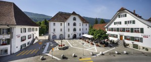
Hotel Balsthal
The Balsthal Hotel proposes a wide and modern variety of offers for gastronomy and seminars. If you're organising a workshop, a business dinner, a new product demonstration, a wedding or a company event, you've found the right place!
All season
Naturpark Thal - Von Hauenstein nach Balsthal in 6.30 Stunden, durch Jura-Buhenwald, vorbei an prächtigen Höfen mit gepflegten Gärten und Burgruinen. Aussichstpunkte mit Blick auf die höchsten Jura-Gipfel und das Mittelland - es lohnt sich!
Wunderschöne Wanderung durch Jura-Buchenwald, vorbei an prächtigen Höfen mit gepflegten Gärten, Burgruinen und Zeugen von der Wehrhaftigkeit der Schweiz in den Weltkriegen, Aussichstpunkten mit Blick auf die höchsten Jura-Gipfel und das Mittelland.
Wanderzeit: 6h 30min

The Balsthal Hotel proposes a wide and modern variety of offers for gastronomy and seminars. If you're organising a workshop, a business dinner, a new product demonstration, a wedding or a company event, you've found the right place!
HOCHFAHREN RUNTERKOMMEN GENIESSEN
HERZLICH WILLKOMMEN
bei uns auf der Tiefmatt am Jurahöhenwanderweg, auf 809 m.ü.M.
To optimise your experience on our website we use cookies. Privacy policy aI agree
