Navigating the Swiss Parks Website
Map
i

Brienzer Rothorn - Lake Eisee - Schönebode

Hiking trail
Time required: 3 hoursLength: 6.13 km

Season

June, July, August, September, October

Contact

UNESCO Biosphäre Entlebuch  
Biosphärenzentrum UNESCO Biosphäre Entlebuch
Chlosterbüel 28
6170 Schüpfheim
Tel. +41 41 485 42 50

www.biosphaere.ch

UNESCO Biosphäre Entlebuch   - Mountain walk with wonderful views at the outset from Lucerne's highest peak

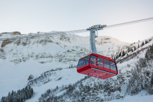
The starting point of the hike is on the ridge of the Brienzer Rothorn, which you can easily reach by aerial cableway: fantastic views of Brienz, Lake Brienz and the Bernese Alps. Descend towards Lake Eisee and from there towards Schönebode.

Route-information

Route-information

Length
6.13 km
Altitude difference descent
1104 m
Time required
3 hours
Level technique
Middle
Level condition
Hard
Height profile view map

Details

Equipment / Equipment rent

Sturdy footwear and something against the rain. Walking poles if you have some.

Signalization

Brienzer Rothorn - Eisee - Schönenboden

Safety advices

Informationen zum aktuellen Zustand des Wanderwegnetzes von Sörenberg-Flühli erhalten Sie täglich auf der Panoramawanderkarte.  

Possibilities for catering

Rothorn Summit Restaurant
Berghaus Eisee

Infrastructure

Aerial cableway Sörenberg - Brienzer Rothorn
Arrival

Starting point
Brienzer Rothorn
Destination
Parkplatz Schönebode

Suitable for

The offer is suitable for

  • Adults

To discover on the trail

UNESCO Biosphäre Entlebuch  

Luftseilbahn Brienzer Rothorn

Auf das Brienzer Rothorn, den höchsten Punkt des Kantons Luzern, gelangen Sie bequem in weniger als 10 Minuten mit der Luftseilbahn.

Infrastructure SummerInfrastructure WinterFunicular
UNESCO Biosphäre Entlebuch  

Gipfel-Restaurant Rothorn

Geniessen Sie von der Gipfel-Terrasse oder im Restaurant mit Panoramafenstern die unglaubliche Aussicht.

RestaurantCafé
UNESCO Biosphäre Entlebuch  

Fototrail Rothorn - sponsored by Raiffeisen

Geschlossen

Herzlich willkommen auf dem #FototrailRothorn - sponsored by Raiffeisen.


Theme trail
Time required: 1 hour 54 minutesLength: 4.65km

Routes in the vicinity

UNESCO Biosphäre Entlebuch  

Fototrail Rothorn - sponsored by Raiffeisen

Geschlossen

Herzlich willkommen auf dem #FototrailRothorn - sponsored by Raiffeisen.


Theme trail
Time required: 1 hour 54 minutesLength: 4.65km

Map